
AVRE further reading
Background
In 2006 AuScope set out to change the way the Australian geoscience community exchanged and accessed data, both a technical and social challenge.
The Government geological and geospatial agencies of Australia, CSIRO and Universities have amassed substantial volumes of data, but were technologically challenged and limited in their capacity to store and dynamically access the data internally, and then deliver online to clients, partners and stakeholders. Further, the organisations developed individual data and information systems to meet their own internal business drivers, which resulted in heterogeneous systems that were unable to be linked together.
The original AuScope Grid achieved a breakthrough by taking a different approach to accessing data. Rather than trying to get each supplier of data to conform to a nationally agreed data model, CSIRO’s Dr Robert Woodcock and his team set out to create a unified system called the Spatial Information Services Stack (SISS) that enabled the exchange of data, with no change required in the underlying databases of the supplier; each data supplier would map from their internal systems to an agreed suite of exchange standards.
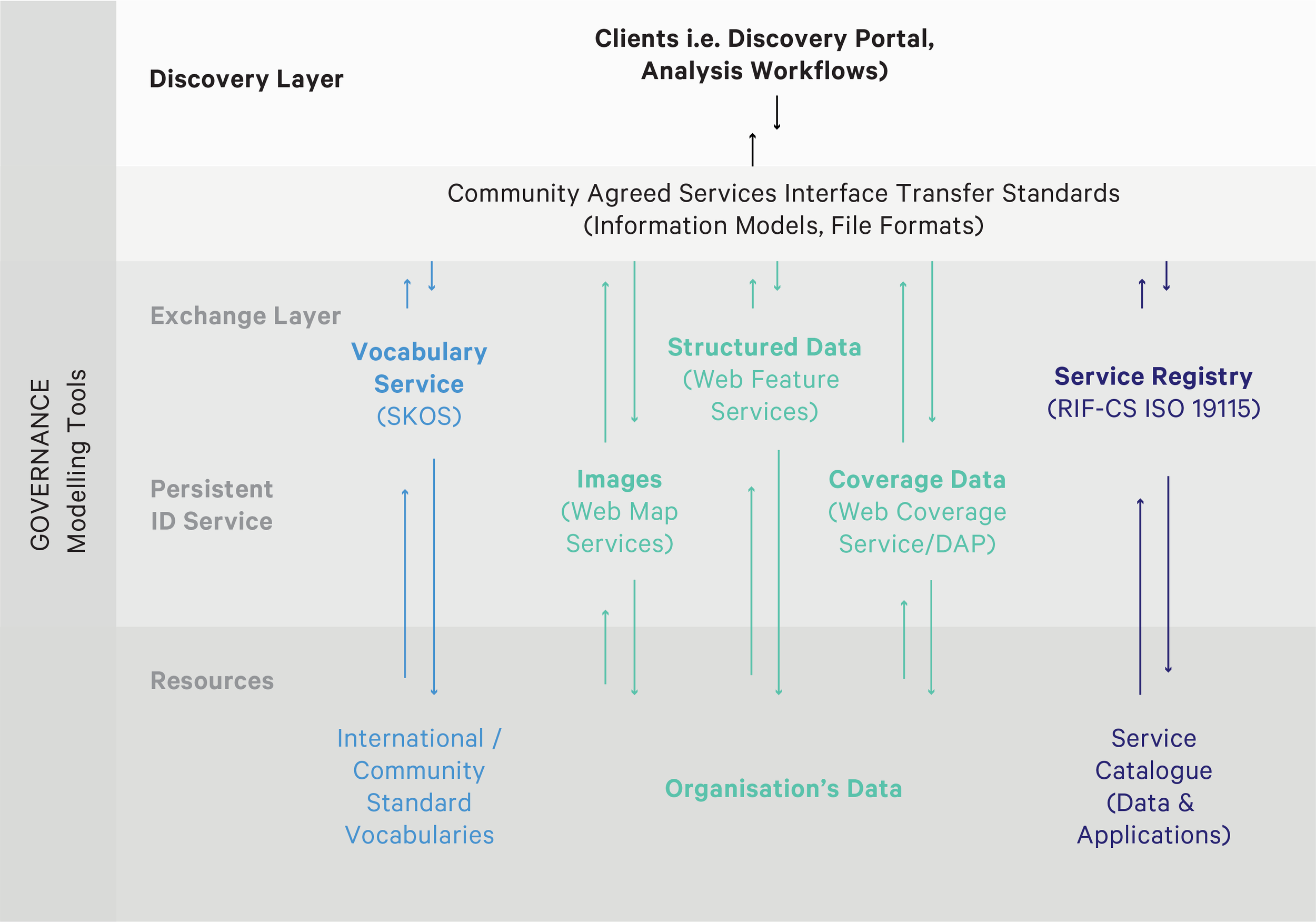
AVRE’s SISS showing the process of making data from heterogenous sources discoverable via the AuScope Discovery Portal.
We have since successfully combined and made accessible historical and new data produced by AuScope and Australian Government geoscience and geospatial agencies, via a suite of data access products.
References
Woodcock, R.; Wyborn, L. Building the Australian Earth Science Grid, AuScope. Preview. 2007; 130:27.
Golodoniuc, Pavel; Klump, Jens; Woodcock, Robert. Leveraging AuScope technology to define distal footprints of mineral ore systems. In: AESC 2016 - Australian Earth Sciences Convention 2016; 26-30 June 2016; Adelaide, Australia. Geological Society of Australia (GSA); 2016. P.171.
Golodoniuc, Pavel; Woodcock, Robert; Wyborn, Lesley; Fraser, Ryan. Leveraging open standards and open data delivery. In: eResearch Australasia Conference 2016; 10-14 October 2016; Melbourne, Australia. Conference Organisers; 2016. 1p.
Golodoniuc, Pavel; Fraser, Ryan; Woodcock, Robert; Wyborn, Lesley. The Spatial Information Services Stack (SISS). In: eResearch Australasia Conference 2011; 6/11/2011; Melbourne, Australia. eResearch Australasia Conference 2011; 2011. 2.
Woodcock, R.; Simons, B.; Fraser, R. AuScope spatial information services stack - deploying an open source infrastructure for scientific spatial information interoperability. In: CSIRO Exploration and Mining, Kensington, editor/s. 3rd eResearch Australasia Conference; 9-13 November, 2009; Novotel Manly Pacific, Sydney, N.S.W.. 2009.
Wyborn, L.; Cox, S.J.D.; Woodcock, R. OneGeology : helping Geological Surveys worldwide to interoperate seamlessly on the next generation internet. In: CSIRO Exploration and Mining, Kensington, editor/s. Proceedings of the 33rd International Geological Congress; Oslo, Norway. 2008.
Cox, S.J.D.; Dent, A.; Esterle, J.; Woodcock, R.M.; Girvan, S.; Mackey, T.; et al. Standardized web-access to geoscience datasets: the SEEGrid WFS testbed. In: CSIRO Exploration and Mining, Kensington, editor/s. GIS and spatial analysis : Annual Conference of the International Association for Mathematical Geology : IAMG 2005, Toronto, Canada, August 21-26, 2005; 2005; Toronto, Ont.. Toronto, Ont.: International Association for Mathematical Geology; 2005. 844.
PROGRAM LEADER
Jens Klump, CSIRO
COLLABORATORS
CSIRO, Data61, University of Melbourne, University of Wollongong, Australian National University, Geoscience Australia and Geological Surveys of NSW, QLD, VIC, WA, TAS and NT and SA.
NCRIS initiatives: NCI, Research Data Australia, Australian Research Data Commons (ARDC), IMOS, TERN and ALA.
DURATION
Since 2006