
Subsurface Observatory
Investigating Earth’s properties & behaviour
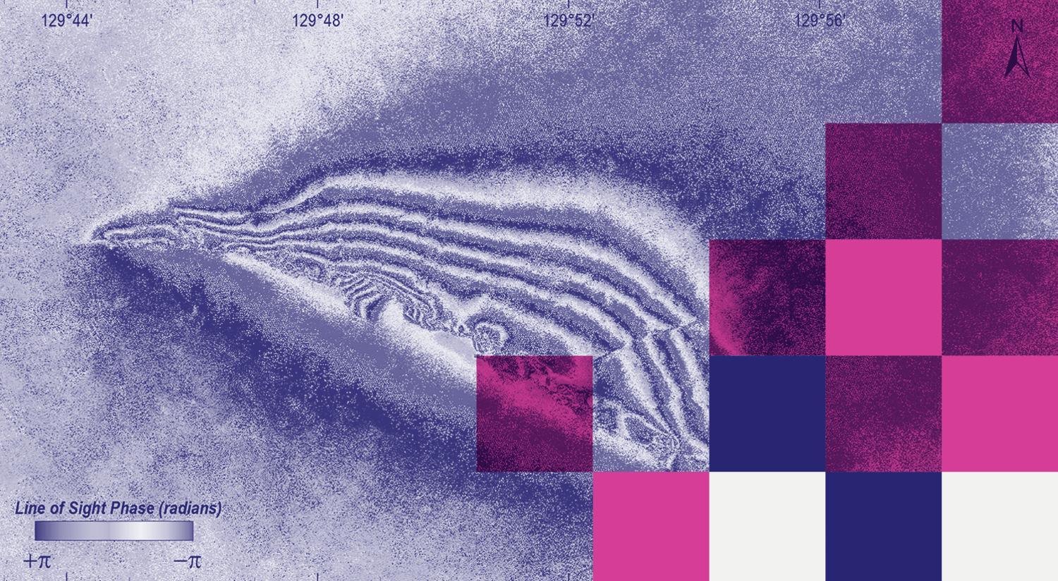
InSAR interferogram showing the spatial pattern of ground surface movement caused by the the 2016 Petermann Ranges earthquake. Image: Dr. Dan Clark, Geoscience Australia.
Our Subsurface Observatory helps geoscientists unlock information about the character of the Australian continent: how it responds to earthquakes, and which parts might be prospective for minerals, energy and water resources.
Our team deploy seismometers to active earthquake areas in Australia and the Asia-Pacific, and use a suite of petrophysical instruments to acquire thermal, structural and geophysical data from deep exploration boreholes across Australia.
Tools & data
Our kit includes field and laboratory-based seismic, geophysical geothermal and petrophysics instruments. Get in touch to learn how we can help with your next project, or:
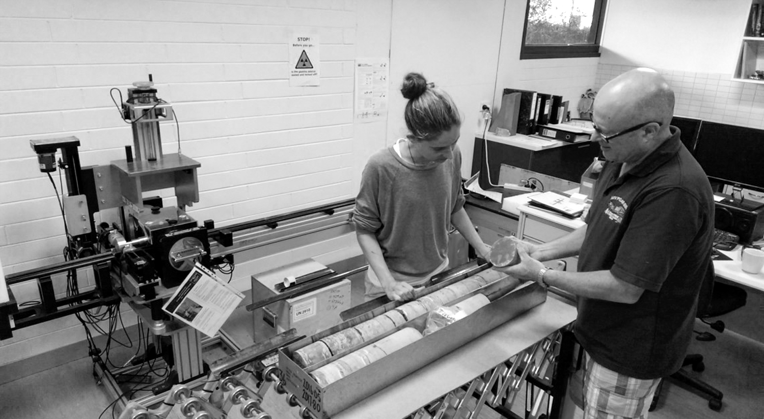
Our team inspecting core in the Subsurface Laboratory.
What We’re Working On
Our seismometer fleets are currently collecting critical data in seismically active regions of Victoria and South Australia, as well as areas of interest in New South Wales. And aftershock instruments are currently monitoring the M7.5 event in Papua New Guinea’s Southern Highlands (Feb, 2018).
In the lab, we are currently applying our Natural Gamma and X-Ray Fluorescence instruments in profiling the potential Geothermal heat production characteristics of a suite of deep core samples from New South Wales. We are also exploring alternative core handling and measurement protocols with a view to increasing the utility of our Multi-Sensor Core Logger.
Achievements
In the last three years, we have worked on a number of projects across Australia with specialist research teams, tertiary institutions, state government geological surveys and federal government bodies. Our achievements include:
The Tynong Project was based on collaboration with Geological Survey of Victoria to extend drilling depth thus enabling optimisation of thermal measurements and subsequent heatflow modelling. In combination with additional borehole analyses and thermal conductivity studies with GSV, this program has contributed significantly to the development of the “Geothermal Heatflow Map of Victoria”.
The Willaura Copper Project with the Geological Survey of Victoria delivered a suite of logging/petrophysical outcomes that were a catalyst for a wider study that subsequently became the Stavely Project.
The Southern Australian Borehole Stress Logging Transect was a collaboration with The Australian School of Petroleum - University of Adelaide and the Department of State Development - South Australia. Borehole image logging was captured on a suite of wells to provide spatial and structural information inboard of the traditional coastal petroleum wells. This project enabled a more comprehensive picture of regional crustal in-situ stress patterns to be developed.
The Lower Darling Morphotectonic Study in conjunction with Geoscience Australia involved deployment of surface seismometers and gravity meter, array of high resolution differential GPS measurements of landforms for comparison with regularly captured RadarSAT scenes. The project was developed, and continues, to contribute to understanding of the complex, near surface geology of this important region.
The Western Victoria Drillcore Program in collaboration with the Geological Survey of Victoria helped establish critical baseline petrophysical values for application in temperature mapping and geothermal modelling of the shallow crust. This was an extension of GSV’s “Seamless” and “3D” programs.
The Petermann Ranges Mw6.0 Earthquake initiated the development of an extensive co-operation among multiple stakeholders including Geoscience Australia, DMITRE (SA), DSTO and the Subsurface Observatory, to deliver temporary monitoring in the epicentral region and to locate a surface rupture, despite difficult conditions. These activities contributed to the development of alternative crustal stress models to explain this significant earthquake event.
At the invitation of CSIRO, the Subsurface Observatory undertook detailed petrophysical characterization of a range of drill cores. The results contributed directly to a study by CSIRO’s collaborators on the NSW CO2 Storage Assessment Project which was coordinated by Coal Innovation NSW. The overall aim of the project was to identify potential storage opportunities on behalf of NSW Resources and Geoscience.
More recently, we have provided an extensive suite of petrophysical data as a foundation to the Stavely Project. This project is a collaboration between Geoscience Australia and the Geological Survey of Victoria to study the regional geology and mineral systems of the Stavely Arc. In partnership with DET CRC, this project made an important contribution to the UNCOVER Australia initiative.
News


PROJECT LEADER
Dr Dan Sandiford
Petrophysics Laboratory
School of Earth Sciences
University of Melbourne
PAST — CURRENT
COLLABORATORS
The Australian School of Petroleum, DETCRC and the CO2CRC; The University of Adelaide, WA and Melbourne; NSW, SA, VIC and WA State Geological Surveys; and CSIRO and Geoscience Australia.
DURATION
Since 2006
ACCESS TOOLS & SERVICES
Dr. Dan Sandiford
IN THE MEDIA


