
Introducing AuScope’s 2021 Pilot Projects

AuScope is embarking on eight collaborative, NCRIS enabled, pilot projects that will help researchers address climate change, natural resources and education challenges. Each project represents an exciting step in building Australia’s Downward Looking Telescope and addressing national geoscience challenges. Here’s why.
Land-2-Sea Geoscience

WATCH: ANZIC is the Australian and New Zealand International Ocean Discovery Program Consortium, part of the 26 nations engaged in deploying state-of-the-art ocean drilling technologies, IODP advances the scientific understanding of the Earth and unifies the international research community to explore Earth’s last frontiers.
Our Land-2-Sea Geoscience project (L2SG) will support ANZIC ( the Australian and New Zealand International Ocean Discovery Program Consortium) and its land-based partner, ICDP (the International Continental Scientific Drilling Program) in deploying new, low-cost drilling technology to retrieve cores from previously inaccessible sedimentary deposits beneath Antarctic ice shelves and sea ice.
These cores will be used to determine the sensitivity of the West Antarctic Ice Sheet to a warming climate and tectonic processes, in turn allowing researchers to provide critical knowledge for regionally-specific climate change mitigation and adaptation strategies. L2SG will also test the feasibility and value of collaborating with ANZIC and ICDP to the Australian geoscience research community.
L2SG is a collaboration between the Australian National University (ANU) and ANZIC (and ANZIC members) and will be led by Dr Sarah Kachovich from ANZIC.
Marine Heat Flow Measuring System
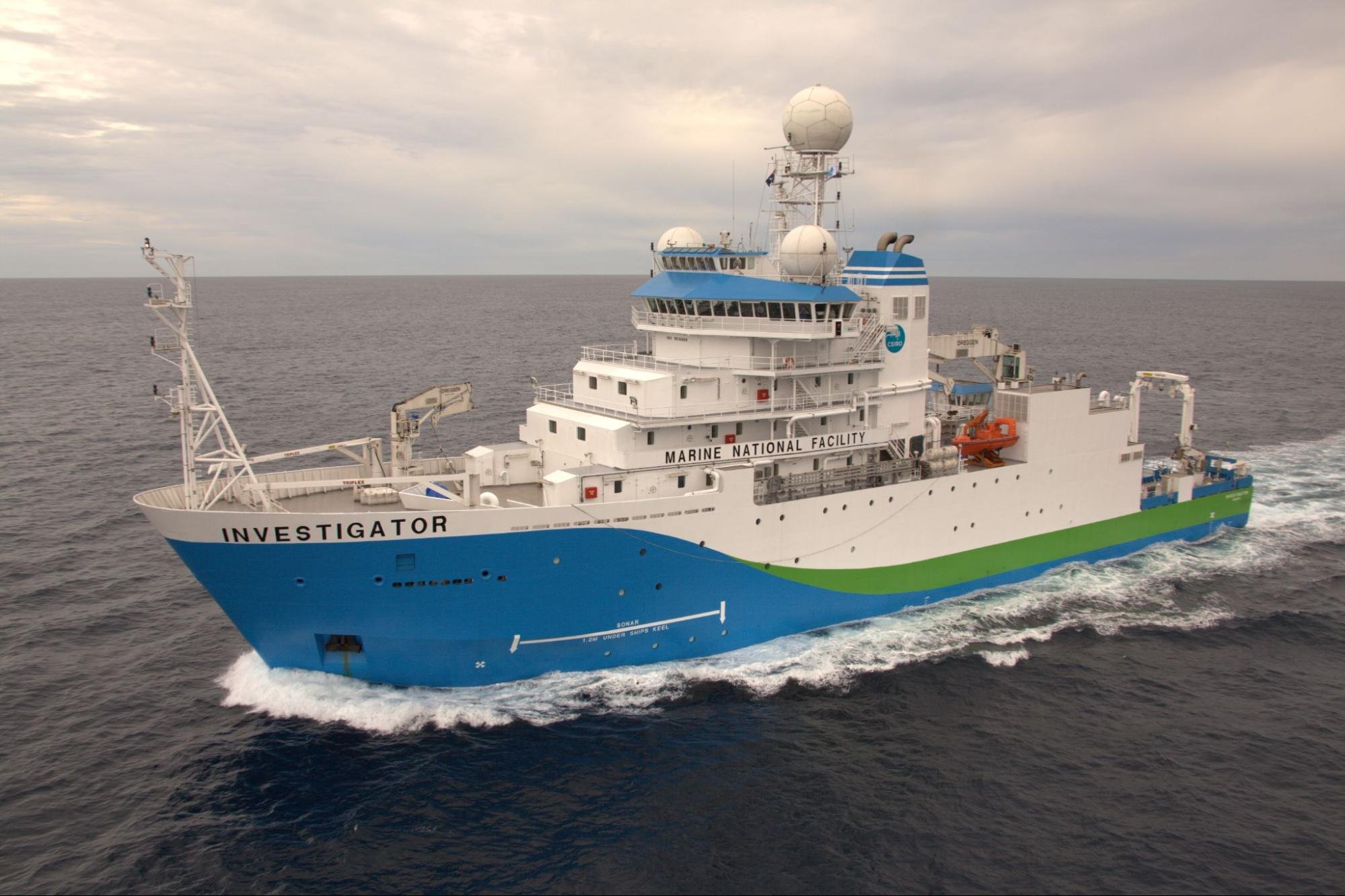
With almost $20 million worth of scientific equipment, this 94m ship is capable of mapping the seafloor at any depth, collecting weather data 20km into the atmosphere, analysing fish species with sonar and revealing the composition of the sea bed 100m below the seafloor. Image and caption: CSIRO
Our Marine Heat Flow Measuring System project (MHFMS) will develop a method to measure heat flow in ocean-floor sediments as part of the sediment coring capability on Australia’s Marine National Facility vessel, the RV Investigator, and the Australian Antarctic Division’s icebreaker, the RSV Nuyina.
Marine geothermal heat flow measurements are important because they can help scientists to better understand, monitor, mitigate, and adapt to the effects of climate change. For example, they can monitor glacier behaviours like flow and melting rates that are sensitive to heating from below.
Marine heat probes in the MHFMS will also enable scientists to gain a greater understanding and management of geohazard risk and mapping of complex marine geological relationships.
A/Prof Jo Whittaker from The University of Tasmania explains that MHFMS fills an important science gap:
“There are very few heat flow measurements conducted onshore of Antarctica because they are hard to get to with all that ice in the way. So instead, we plan to obtain measurements in the offshore Antarctic regions.”
MHFMS will be led by A/Prof Jo Whittaker (primary contact) and Dr Jacqueline Halpin from The University of Tasmania, and Dr Maria Seton from The University of Sydney, in collaboration with The University of Melbourne, the Marine National Facility and the Australian Centre for Excellence in Antarctic Sciences.
GPlates In Schools

Australia's National Science Statement explains a recent (2017) central aim of the Australian Government to engage all Australians with science. As part of our response, we are enabling the GPlates In Schools program (GISP), which incorporates the development of an educational app that will help students and citizen scientists around the world learn about plate tectonics, Earth processes and Earth’s climate.
Project leaders, Dr Maria Seton and Professor Dietmar Müller from The University of Sydney say that GIS will provide interactive, high-quality geoscience modelling visualisation to schools, providing teachers with a valuable teaching resource and giving the next generation of geoscientists a chance to experience Gplates and imagine what is possible. Both researchers are excited about GIS’ accessibility component:
“This program will fill a gap in geology-focused educational material in schools, and help bridge educational inequities as the program will be equally accessible to urban and regional students. It will also help students with disabilities who may not be able to attend field excursions or other forms of STEM training.”
Common Framework For Inference

An overview of CoFI, which acts as the glue between data analytics, research and education. Users contribute the jigsaw pieces and CoFI connects them together. Image: Professor Malcolm Sambridge
In AuScope’s Common Framework For Inference project (CoFI), researchers will build an open and flexible software platform that enables the wider research community to more effectively undertake inversion (a tool to understand subsurface properties using field data). CoFI will also help educators to better teach inversion to geophysics students through the provision of interactive examples.
CoFI will be the world's first independent transportable framework for inversion, offering researchers a flexible high-level programming language that expresses inversion problems and connects them to solutions. Project leader, Professor Malcolm Sambridge from The ANU explains why this is so exciting:
“Typically geoscience researchers who develop inversion methods need problems to test them on, and those who need to solve inversion problems need leading-edge algorithms to solve them. The idea behind CoFI is to allow the two to meet in the middle, while also providing an ease of use platform for educators. We are excited to be embarking on this new project, the first of its kind in the world, with our partners in AuScope and CSIRO.”
CoFI will be a collaboration between The ANU, CSIRO’s Deep Earth Imaging Future Science Platform and the University of Durham.
Supporting Australian Atom Trap Trace Analysis

Dr Rohan Glover using the Atom Trap Trace Analysis (ATTA) facility at The University of Adelaide, which, with AuScope co-funding, will soon feature a new geoscience capability. Image: University of Adelaide
AuScope is co-investing in the development of the Atom Trap Trace Analysis Facility (ATTA) at The University of Adelaide (UoA), namely precision noble gas radioisotopes measurement, to help researchers understand precious groundwater systems in Australia. The Supporting ATTA pilot project (SATTA), which is also supported by the Australian Research Centre, CSIRO and a consortium of Universities, will serve the research needs of hydrogeology, oceanography and glaciology communities, as well as government departments (water resource management, EIA), and industry (mineral exploration, risk management).
Project leader, Dr Rohan Glover says the global capacity for precise measurement of noble gas radioisotopes is extremely limited, and why the development of SATTA for geoscience matters:
“ATTA is an exciting new quantum technology taking state-of-the-art physics techniques to answer big questions about Australia’s groundwater resources. The facility at the University of Adelaide will be only the fourth such facility in the world and will provide a sovereign capability, crucial to key Australian sectors.”
SATTA will be led by Professor Andre Luiten and Dr Rohan Glover from UoA via the Institute for Photonics and Advanced Sensing (IPAS), a transdisciplinary scientific capability that creates new sensing and measurement technologies.
National Geophysical Validation Line
AuScope’s National Geophysical Validation Line project (NGVL) will enable the development of national geophysics calibration through collation, analysis, modelling, acquisition and access of multi-scale land- and air-based geophysics data. Data calibration plays a critical role in benchmarking geophysical data acquisition, processing, and inversion technologies, allowing researchers to obtain high-quality, reliable, and repeatable data and better understand Australia’s water, energy, and minerals resources.
NGVL, led by Dr Aaron Davis from CSIRO, is a collaboration with Geoscience Australia, Curtin and University of Western Australia and Western Australian government agencies.
Mapping Australia’s Crust In Four Dimensions
This MAC4D project involves the upgrade of ANU’s SHRIMP-II mass spectrometer (age dating instrument) to enable the measurement of lithium, beryllium, boron, magnesium, silica, calcium and potassium isotopes. It also involves cataloguing a unique collection of more than 3000 zircon samples and beginning measurements of oxygen and uranium-lead isotopes.
Finally, it will encourage Australian users to help seed new projects using the SHRIMP facility through the provision of an AuScope Access Awards. Data will be made accessible via AusGeochem, where four-dimensional integrated isotope-age maps can be created to help find critical minerals.
This project, led by Professors Penelope King and Ian Williams from The ANU is a collaboration together with Arise Geosciences, CSIRO, Curtin University, Geochronology & Isotope Geochemistry Pty Ltd, Geoscience Australia, Griffith University, Macquarie University, UNSW, UQ and the University of Wollongong.
AGN+
Unlike Europe and the US, Australia has not had a trusted domain repository for geochemistry data. By increasing the number of data partners, AusGeochem will become the first national-scale cooperation to deliver systematic collection, aggregation and integration of geochemistry data from rocks on Earth, and across the solar system.
This AGN+ project will enable a major expansion of the AuScope Geochemistry Network (AGN) beyond the three existing institutional nodes, adding new institutions with major concentrations of active geoscience research infrastructure and collections of geological samples and data of national importance.
AGN+ will be led by Professor Brent McInnes and Dr Alexander Prent (key contact) of Curtin University.
AUTHORS
Philomena Manifold in collaboration
with Pilot Project Leaders and Jo Condon